 | |
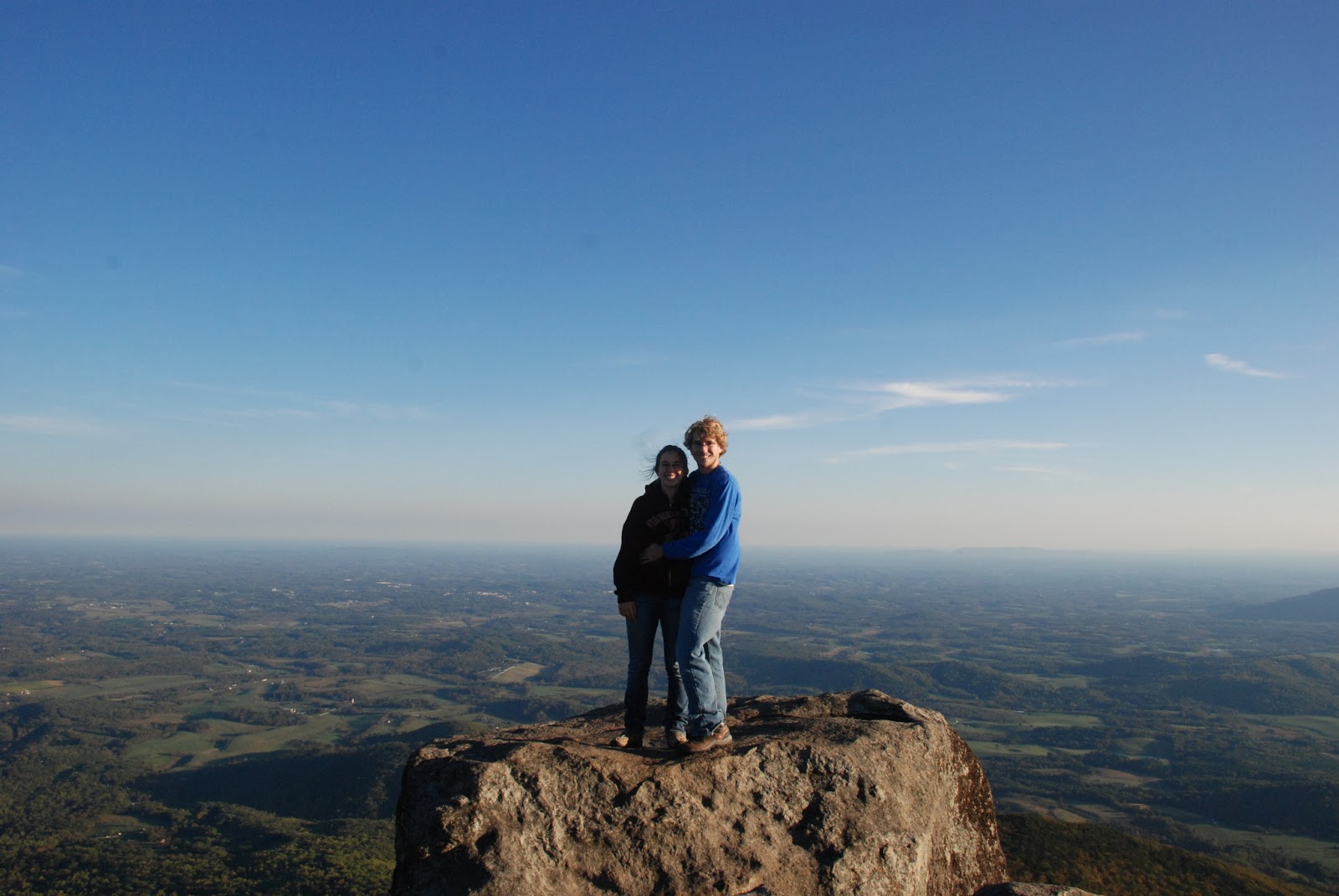
| View from Angel's Rest |
 |
| Large rock near the overlook |
Parking Coordinates: N37° 19.75302 W80° 45.04795
Length: 1.5 mile each way (3 miles total)
Difficulty:moderate-strenuous just because of incline
Payoff: a bit of a view, but not the best payoff in my opinion
Parking Fee?: no
Rock Scrambling?: no
Free Camping Opportunities?: yes
Pet Friendly Hike?: yes
Longer Post About Angel's Rest
Parking Fee?: no
Rock Scrambling?: no
Free Camping Opportunities?: yes
Pet Friendly Hike?: yes
Longer Post About Angel's Rest
I have only done this hike once, probably because I wasn't a huge fan of the "effort:reward ratio" on this one. The hike is relatively short and makes for a good day hike, but the path up is relatively uninteresting (and quite steep) and unlike many of the other hikes in the area, when you arrive at the lookout, you'll find that it's not much more than one large rock (not the rock shown in the image above). The views are nice and if you continue onto the AT you'll be able to see some more views that are partially obstructed by trees. This one was fun for a one-time adventure, though.
Bald Knob

Parking Coordinates: 37.354717, -80.539743
Length: .5 miles each way (1 mile total)
Difficulty:moderate just because of incline
Payoff: beautiful views at many rock outcroppings at the top
Parking Fee?: no
Rock Scrambling?: no
Free Camping Opportunities?: unsure
Pet Friendly Hike?: yes
Longer Post About Bald Knob
Parking Fee?: no
Rock Scrambling?: no
Free Camping Opportunities?: unsure
Pet Friendly Hike?: yes
Longer Post About Bald Knob
This is a quick, but beautiful hike near Mountain Lake Lodge. The trail starts off of the main road, before you reach the lodge and up a gravel road almost directly across the main road from the parking lot designated for day visitors. Start up the gravel road until you reach the signpost that directs bald knob hikers to a trail on the right. Follow the trail until you reach the views (you'll know you're just about at the top when you see the large rocks to your left).
Barney's Wall
Parking Coordinates: N37° 21.23028 W80° 35.93917
Length: 8 miles round trip (2 to cascades, 2 past cascades, then 4 back)
Difficulty: moderate
Payoff: great views! You'll pass the cascades on your way, so you can enjoy that as well.
Parking Fee?: yes (same lot as the cascades)
Rock Scrambling?: no
Free Camping Opportunities?: no
Pet Friendly Hike?: yes
Rock Scrambling?: no
Free Camping Opportunities?: no
Pet Friendly Hike?: yes
Barney's wall is actually an extension of the cascades hike. If you walk to the cascades, then follow the stair up to a small cleared area, you will have the option of continuing on to Barney's wall or taking the fire trail back to the parking lot. Barney's wall is simply a cliff overlook. When we went, we watched a storm roll in. Unfortunately, this experience also resulted in us getting soaked to the skin and slipping and sliding our way back down the trail, but it was a great experience. If you do the cascades, you may as well make the extra 2 mile trek up to Barney's Wall to get the full experience.

Black Ridge Trail

Parking Coordinates: 36.811439, -80.350606 (Rocky Knob Visitor Center)
Length: 3 mile loop
Difficulty: easy-moderate
Payoff: great views! Various terrain (fields, woods, creek, etc.)
Parking Fee?: no
Rock Scrambling?: no
Free Camping Opportunities?: no?
Pet Friendly Hike?: yes
We started at the visitor center, and took the nature trail off of the back side of the parking lot (see map below). The nature trail then connect to the blue blazed trail. Take that trail across a creek and alongside a grassy road with a fence on your right side. Eventually, you will see a large blueish house with a giant garage and gorgeous views ahead and on the right. There is a left-hand turn just before that to stay on the trail. That will take you to the blue ridge parkway and over a ladder into a cow pasture. Follow the worn down trail in the pasture until you reach the juncture with the Rock Castle Gorge trail. Make a left and follow the trail past a downed tree and eventually reach another ladder to take you out of the pasture. It's a short jaunt through the woods until you will reach the parkway pulloff and overlook. You can technically follow the trail back to the visitor center, but you will see the visitor across the street once you are at the overlook.

Bottom Creek Gorge


Parking Coordinates: N37° 7.91298 W80° 10.83627
Length: 4-5 miles total trails, but loops vary in length and you can adjust your hike accordingly
Difficulty: easy
Payoff: views of the 2nd highest waterfall in Virginia, space to wander along the creek
Parking Fee?: no
Rock Scrambling?: no
Free Camping Opportunities?:
Pet Friendly Hike?: yes
Longer post about Bottom Creek Gorge
This hike provided a nice variety of scenery without too much difficulty in hiking. Unlike many hikes with a view, this hike is not an uphill climb to the top and then a downhill hike back. Rather, it consists of 3 different loops + an entrance road that meander around with small ups and downs along the way. You can choose to make the hike shorter or longer as you please. We did one of the longest loops possible without backtracking over any legs of the trail in about 4.5 miles. The view of the waterfall is quite impressive, albeit very different from what I had been expecting!
Buffalo Mountain
 |
| View from Buffalo Mountain summit |
 |
| View of Buffalo Mountain from Rock Castle Gorge |
Parking Coordinates: N 36º 47.6338 W080º 27.9389
Length: 1 mile each way (2 miles total)
Difficulty: fairly easy
Payoff: great views! A nice picnic spot, although the wind might blow your food away.
Parking Fee?: no
Rock Scrambling?: no
Free Camping Opportunities?:
Pet Friendly Hike?: yes
Longer Post about Buffalo Mountain
This hike was a quick one - perfect for a chilly day before the start of classes. It took us about an hour and fifteen minutes to get to the parking area from Virginia Tech, but I'm glad we did it. The hike itself is quick - it took my friends and I a little over 20 minutes to get to the top. Had I been in remotely decent shape, this could have been quicker. We were back to the car in an hour after spending some time to enjoy the views at the top. I would definitely recommend this one - the effort to reward ratio was about as good as it gets without parking your car at a scenic overlook.
 |
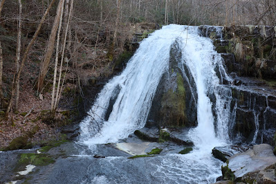
| The Cascades |
Parking Coordinates: N37° 21.23028 W80° 35.93917
Length:4 miles round trip (although you have the choice of taking the main trail or the fire road)
Difficulty: easy
Payoff: gorgeous waterfall! In the summer you can swim here, albeit it is quite cold!
Parking Fee?: yes ($3)
Rock Scrambling?: no
Free Camping Opportunities?: no
Pet Friendly Hike?: yes
Longer Post about the Cascades (1)
Longer Post about the Cascades (2)
This hike is a must do for every Hokie. Not only is it probably the most well-known, well-traversed hike within the Hokie community, it also has some incredibly nice payoff. The waterfall is gorgeous and the hike can be done in any season. I've been swimming here before, though if you want to do so, you may prefer to take a leap of faith rather than easing yourself in slowly, because the water is cold. In the winter, I've heard that the waterfall occasionally freezes over, although I have yet to see this. The hike is scenic, fairly easy, and along a stream. Stairs and bridges are put in place to help you make your way to the waterfall. It's a popular hike, but the waterfall makes it worth it. If you continue on once you reach the cascades, you can hike to Barney's Wall (a scenic overlook) which is much less traversed, but also a worthwhile endeavor.


Parking Coordinates: 37.3793468795,
-80.2502299672
Length: ~2.7 miles round trip, but this is just an out-and-back on the AT with a not-too-obvious vista, so you can really make it as long or short as you'd like.
Difficulty: easy - moderate
Payoff: creek, not heavily trafficked (at least while we were there), woods walk, small view (nothing spectacular, even in winter with leaves down)
Parking Fee?: no
Rock Scrambling?: no
Free Camping Opportunities?: yes
Pet Friendly Hike?: yes
Parking Fee?: no
Rock Scrambling?: no
Free Camping Opportunities?: yes
Pet Friendly Hike?: yes
Note - we hiked this northbound from the Craig Creek Road Parking Area on the AT Interactive Map to the closest vista on the interactive map (at 37.3736760552992,
-80.2468782907226). The walk out was pleasant, but don't be expecting a spectacular (or even completely obvious) vista. We had marked the vista on our GPS so we knew when we were there and you could see from the ridge through the trees, but this isn't a hike that you should do just for the views. Better to save this one for when you want a quiet, contemplative walk in the woods and the listen to the sound of some creeks.
 |
| View from near the top of the marbleyard looking down |
 |
| View looking up the marbleyard |
Parking Coordinates: 37.57119,-79.491723
Length: about 1 mile to the base of the marbleyard
Difficulty: easy walk to the marbleyard, but the scramble would be difficult for anyone without good use of both arms and legs.
Payoff: a unique rock scrambling experience and some nice views, especially in the summer and fall
Parking Fee?: no
Rock Scrambling? yes, very much so
Free Camping Opportunities?: yes
Pet Friendly Hike?: no, not really. Dogs are allowed, but it would be a struggle to climb the marble yard with no opposable thumbs!
Longer Post about Devil's Marbleyard (1)
Longer Post about Devil's Marbleyard (2)
Longer Post about Devil's Marbleyard (3)
This hike has to be one of my all time favorite hikes in the area. From Virginia Tech, it'll take you about an hour and a half driving to get to the trail head. You'll take the Belfast Trail upon arrival and follow it for roughly a mile. At around this point, you should begin to see signs of the boulder field to your left. Every time I hike this trail, I forget how magnificent the rocks are. From the base, you can't see the top of the boulder field, but if you start scrambling up the rocks, you'll realize that there are several "climbs" and several "plateaus" before you make it to the top. The boulders get bigger as you near the top, so you'll have to navigate over and around the rocks to find the best route. I've found that the best views are when you climb partway and turn around. Once you reach the top, the treeline obscures some of the gorgeous views, so although it's fulfilling to get there, enjoy the best views as you make your way up. If you like rock scrambling, this is a must do.
Parking Fee?: no
Rock Scrambling?: yes, a bit near the top
Free Camping Opportunities?:
Pet Friendly Hike?: yes, although your dog won't be able to climb the "tooth" so must be able to wait or be tied at the bottom
Dragon's Tooth
 |
| The "tooth" itself |
 |
| Part of the view from near the base of the "tooth" |
Parking Coordinates: N37° 22.72818 W80° 9.36697
Length: 5.7 miles round trip (although this is an out and back hike)
Difficulty: moderate
Payoff: a very cool looking rock at the top and nice viewsParking Fee?: no
Rock Scrambling?: yes, a bit near the top
Free Camping Opportunities?:
Pet Friendly Hike?: yes, although your dog won't be able to climb the "tooth" so must be able to wait or be tied at the bottom
This hike is another must do for Virginia Tech students as can be seen by the Hokie bucket list. I've done it a few times, and although other sources have it listed as a "strenuous" hike, personally, I believe that moderate is a better description. It's more technical than McAfees or the Cascades (rocky at parts, but still no real "rock scrambling" until you get to the top and want to climb up the tooth) and uphill, but nothing that an average, fit adult or child couldn't do.
Fallingwater Cascades

Parking Coordinates: 37.46846, -79.58028 (this is the Flat Top lot, but the Fallingwater hike starts just across the parkway from this lot)
Length: 1.7 mile loop (can be tacked onto the Flat Top hike if you want a 7.7 mile hike total)
Difficulty: easy-moderate
Payoff: nice waterfall, and it's a loop so you get different views/paths the whole time
Parking Fee?: no
Rock Scrambling?: no
Free Camping Opportunities?: ?
Pet Friendly Hike?: yes
Pretty, quick, and steep little hike. From parking area, cut across the blue ridge parkway to the trail. Turn right at the junction that you will come across shortly. The trail will pass another parking lot in a few tenths of a mile and will then start to descend past the waterfall.
 |
| view from one of the overlooks |
 |
| Me at an overlook |
Parking Coordinates: 37.605052,-79.388155
Length: ~ 9 miles round trip (though this needs to be done as an out and back because the connecting trail (that would enable it to be done as a loop) is entirely overgrown as of Sept, 2013).
Difficulty: moderate
Payoff: nice viewsParking Fee?: no
Rock Scrambling?: no
Free Camping Opportunities?:yes
Pet Friendly Hike?: yes
Longer Post about Fuller Rocks/Big Rocky Row
Hay Rocks/Carvin Cove
 |
| View from one of the overlooks |
 |
| The ridge trail |
Parking Coordinates: 37.39086, -79.90620 (by guard rail)
Length: 8 miles total (this is an out-and-back hike)
Difficulty: moderate
Payoff: beautiful views near Roanoke
Parking Fee?:
Rock Scrambling?: no
Free Camping Opportunities?: ??
Pet Friendly Hike?: yes, but a dog will struggle to get to the top of Hay Rock once you reach it (I did too!).
Longer Post about Hay Rocks/Carvin's Cove
Pet Friendly Hike?: yes, but a dog will struggle to get to the top of Hay Rock once you reach it (I did too!).
Longer Post about Hay Rocks/Carvin's Cove
This hike may have an obnoxious number of power lines along the way, but it's otherwise a good hike with an enjoyable bit along the ridgeline before you reach Hay Rock. I struggled to get to the top of Hay rock, so I enjoyed my lunch at the bottom!

High Rocks

Parking Coordinates: 36.906414, -81.042438
Length: ~2.6 miles total (this is an out-and-back hike)
Difficulty: moderate with more strenuous steep patches
Payoff: beautiful views
Parking Fee?: no, BUT you are supposed to have a hunting permit, fishing permit, trapping permit, boat registration, or DGIF membership on you.
Rock Scrambling?: no
Free Camping Opportunities?: ??
Pet Friendly Hike?: yes.
Pet Friendly Hike?: yes.
Nice hike. Short, but some steep patches made it moderate to strenuous at parts. Rocky trail with beautiful views. Easy to follow.
Kelly's Knob
 |
| view from Kelly's knob |
 |
| Some rock structures at the overlook |
Parking Coordinates: 37.372704, -80.446211
Length: 2.1 miles each way (out and back)
Difficulty: moderate (steep ascent for first .2 miles, then not too bad)
Payoff:views in the direction of campusParking Fee?: no
Rock Scrambling?: yes, but only if you climb around the lookout rock. Otherwise, no.
Free Camping Opportunities?: yes
Pet Friendly Hike?: yes
Longer Post about Kelly's Knob
This is a fun little hike that I've done several times. The first 2 tenths of a mile always kills me, but after that, it's a simple little walk through the woods until you come out at the rock overlook. Beware, parking here is really just an offshoot of the gravel road and the road is quite narrow and steep. From the parking offshoot, head across the street and up the steep ascent on the AT. Eventually the white blazed AT will meet a blue blazed trail with a sign to Kelly's knob. Turn right onto the blue blazed trail and you'll be at Kelly's knob in just a few hundred yards.
 |
| A sunrise view in the winter |
 |
| The overhanging rock |
Parking Coordinates: N37° 22.80642 W80° 5.3778
Length: ~8 miles round trip (though this is an out and back hike)
Difficulty: moderate
Payoff: beautiful views and a nice place to go for a sunrise hikeRock Scrambling? no, not really. Even the lookout rock is fairly flat.
Free Camping Opportunities?:
Pet Friendly Hike?: yes
Longer Post about McAffee's Knob
This is a nice hike. I've done it as a sunrise hike and during the daytime. It is mostly just a simple dirt path through a woodsy area that eventually leads to a gorgeous overlook. On the sunrise hike, there was a bit too much cloud coverage for a great sunrise or spectacular views, but on my other trip here, the views were perfect. As it was, the views of the sunrise were still nice. If you're a Hokie, it's a must do before you graduate.
Mill Creek Nature Park
 |
| The first waterfall ascending the catwalk trail. |
Parking Coordinates: 37.316975, -80.793470
Length: varies based on which trails you choose. Shorter loops start at ~1 mile, but trip could be extended to 5+ miles.
Difficulty: also varies. Lower loop was easy. Butternut to waterfall trail to catwalk trail was moderate/strenuous.
Payoff: beautiful waterfalls, likely solitudeRock Scrambling? no, not really.
Free Camping Opportunities?: yes. There is a brand new looking shelter too with a picnic table just off of the butternut trail.
Longer Post about Mill Creek Nature Park
Mill Mountain Park (to Roanoke Star)

Parking Coordinates: 37.24933744234765, -79.9217971335043
Length: varies based on which trails you choose. The Star-Woodthrush Connector to the Star Trail and back again makes for a 3.3 mile out-and-back
Difficulty: moderate. The hike is a steady, but not too steep uphill to the star.
Payoff: Roanoke star and views of Roanoke (note that you can drive to this location as well)Rock Scrambling? no.
Free Camping Opportunities?: not that I am aware of.
Pet Friendly Hike?: yes
Longer Post about Mill Mountain
 |
| Longhorn at Mt. Rogers |
 |
| One of the many overlooks |
Length: 8.2 miles round trip
Difficulty: moderate
Difficulty: moderate
Payoff: gorgeous views the entire hike up, "wild" ponies, highest point in VA
Parking Fee?:
Rock Scrambling?: no
Free Camping Opportunities?: yes
Pet Friendly Hike?: yes
Longer Post about Mount Rogers
Absolutely gorgeous hike. The summit doesn't provide any views, but the views on the way up make it well worth it.
Parking Fee?:
Rock Scrambling?: no
Free Camping Opportunities?: yes
Pet Friendly Hike?: yes
Longer Post about Mount Rogers
Absolutely gorgeous hike. The summit doesn't provide any views, but the views on the way up make it well worth it.
Peaks of Otter - Flat Top (from Sharp Top lot)
 |
| Casey and I at the top |
 |
| Small lake near the visitor center |
 |
| The "ordinary" |
 |
| Another view from the top |
Parking Coordinates: N37° 26.6064 W79° 36.5517 - if you park at these coordinates, you will end up in the Sharp Top parking lot - from here you can easily walk to the Flat Top trail (follow the directions below)
Length:Different sources will tell you different lengths. The way that we did it (parking in the Sharp Top lot and walking to the trail) was probably about .5 miles to the start of the trail and then 1.8 up. So totaling about 4.6 miles (out and back)
Difficulty: moderate-strenuous - those 1.8 miles are almost entirely uphill.
Payoff: nice views in both directions - and a gorgeous view of Sharp Top mountain
Parking Fee?: no
Rock Scrambling?: no, not really.
Free Camping Opportunities?: no
Pet Friendly Hike?: yes
Longer Post about Flat Top
This hike proved to be a testament to how out of shape I am. The trip to the base of the trail was easy. The trail itself? Let's just say I need to start exercising. After about 50 stops to catch my breath and a few dozen proclamations of "and WHY do I say I like hiking!?", we finally made it to the top. I was quickly reminded of the reason why I love to hike when I saw the views. This trail is much less populated than the nearby Sharp Top and the views are just as nice in my opinion. Personally, I liked flat top a bit better just because it felt less manufactured There were no man-made rock walls surrounding the edges at the peak, no stairs built into the trail, and much more solitude. Despite the steady (and slightly painful for those such as myself) ascent, the views are well worth it. The large rock at the top provides a nice place to picnic.
Walking directions from Sharp Top Parking lot (coordinates above): from the sharp top parking area, walk in the direction of the visitor center (towards the BRP). Shortly before you hit Rt. 43, you'll see a little sign to the right for "Lake Trail." Follow this trail for just about a tenth of a mile until you can take a left and cross Rt 43. After you cross Rt 43, follow the trail through the woods until you hit the paved trail around the lake. Follow this paved path for a short ways until you see a little wooden cottage (what was once an "Ordinary"). Take a sharp right past the Ordinary down a tiny hill to a paved road. Follow the paved road for about .3 miles until you see a sign for "Flat Top" to the left. Follow that trail to the top. There is also a "Flat Top Parking area", which should take you to the peak a different way, but at the time of our climb, the road to that lot was closed, so we used the directions above.
Peaks of Otter - Flat Top (from Flat Top Lot; alternative route)

Parking Coordinates: 37.46846, -79.58028
Length: 6 miles total (done as an out and back). You can add 1.7 miles if you choose to also do Fallingwater Cascades.
Difficulty: moderate
Payoff: nice, quiet hike with some pretty views
Parking Fee?: no
Rock Scrambling?: no
Free Camping Opportunities?: ?
Pet Friendly Hike?: yes
This is the other route up Flat Top which is workable as long as the parkway gate isn't closed past the visitor center. From this parking area, the trail is obvious (at the back/right side of the parking lot)
Peaks of Otter - Harkening Hill
 |
| a view from Harkening Hill |
 |
| Boo finds the only puddle on the mountain |
 |
| it's quite green! |
Parking Coordinates: N37° 26.6064 W79° 36.5517 (or at the visitor center across the street)
Length: 3.2-3.3 mile loop
Difficulty: easy
Payoff: nice greenery in the spring/summer, some views (albeit not up to par with Sharp Top or Flat Top), stream
Parking Fee?: no
Rock Scrambling?: no
Free Camping Opportunities?: no
Pet Friendly Hike?: yes
Longer Post about Harkening Hill
Free Camping Opportunities?: no
Pet Friendly Hike?: yes
Longer Post about Harkening Hill
This hike is the smallest and only loop trail among the three Peaks of Otter. We only encountered one other hiker while on this trail, leading us to believe that it's not as well traversed as the other two trails (Sharp Top especially). At some points, it felt like more of a leisurely walk than a hike, but it was a nice trail overall.
 |
| Casey and I at the top of Sharp Top |
 |
| Some rock formations at the peak, plus a view of the rock walls |
 |
| View of Sharp Top from Flat Top |
Parking Coordinates: N37° 26.6064 W79° 36.5517
Length:3.6 miles round trip (this is an out and back hike)
Difficulty: steep climb to the top, but you'll be aided by stairs
Payoff: nice views, plus a little cottage built at the top (just to explore, not to sleep in!)
Parking Fee?: no
Rock Scrambling?: no, but stairs are built into the trail at points and rocky outcroppings at the top.
Free Camping Opportunities?: no
Pet Friendly Hike?: yes
Longer Post about Sharp Top (1)
Longer Post about Sharp Top (2)
Sharp top was a fun, albeit highly populated hike. Unlike most hiking that I've done in Southwest Virginia, Sharp Top was busy. I enjoyed it, but everything felt a bit "manufactured." The peak has rock walls along the edges and many of the ascents on the trail had built in stairs. That being said, it was a nice little day hike with a real (paved) parking area (if I recall, there were bathrooms as well!). Plus, you won't be disappointed by the views on a nice day.
Parking Fee?: no
Rock Scrambling?: no
Free Camping Opportunities?: no
Pet Friendly Hike?: yes
Longer Post about Read Mountain
This hike, unlike many that you might find in Southwest Virginia is situated adjacent to a very Northern Virginia-esque suburb. That said, a little sign will point you down a driveway squeezed in between two family homes which leads to the trailhead. The trail isn't terribly difficult and leads you to a nice walk along the ridge which eventually provides some nice overlooks. I had been hoping for a bald knob at the top; however, and unfortunately, this hike does not provide that. Never-the-less, the hike was a perfect one for a nice early Spring day on my drive back to Blacksburg from Smith Mountain Lake.
Parking Fee?: no
Rock Scrambling?: no
Free Camping Opportunities?: yes
Pet Friendly Hike?: yes
Longer Post about Rice Fields
Parking Fee?: no, at least not at the lower lot
Rock Scrambling?: no, but it's quite the trek out of the gorge (or into it, depending on direction of loop)
Free Camping Opportunities?: yes - though a permit is required
Pet Friendly Hike?: yes, but you will cross through cow pastures
This one has an interesting story. My friends and I set out to make a one night backpacking trip out of this loop. We checked out different sources to find the hiking information and directions to parking areas, not realizing that this is not a hike with only one trail head. Oops. We expected to hike 3 miles down into the gorge, camp at the back country camping location and then proceed to ascend about 7 miles the following day until we had completed the loop and were back at the car. Unfortunately, our parking coordinates did not match up with the hiking guide. There are TWO camping areas on this trail - one free "back country" area (which is still quite manicured and complete with bear boxes and fire pits) and one paid car camping area. Having done little research before embarking, when we parked a few hours before sunset and saw signs labeled "camping" we headed in that direction. We realized shortly that we were most definitely ascending, not descending, but with darkness coming, headed on our merry way. Three miles and about 300 stops later (I was beyond a little out of shape) we made it to a camping area - the car camping area. With debit cards, but no cash and the rangers station closed up for the night, we trekked over to an office where fortunately someone was still working. He was kind enough to allow us to sleep for free in the car camping zone. Moral of the story - recognize that there are two main parking areas for this trail. One is located at the car camping area (where we had meant to park) and one is located near the back country camping area (where we had unknowingly actually parked). If you do the trail counter clockwise (as we did), you will start near the back country camping area, make a steep 3 mile ascent out of the gorge and then a steady 7 mile descent into it. Obviously, clockwise will be the opposite.
Despite our failure to plan well, this hike was great fun. While there was no real "peak" to this hike, there were several pretty overlooks along the way and the trail passed through several landscapes, including a cattle field. The cattle were skittish, but quite curious about us hikers. In order to go backcountry camping, you are supposed to obtain a free permit which you should be able to get at the upper parking lot (the one near the car camping area)
Parking Fee?: no
Rock Scrambling?: no, but stairs are built into the trail at points and rocky outcroppings at the top.
Free Camping Opportunities?: no
Pet Friendly Hike?: yes
Longer Post about Sharp Top (1)
Longer Post about Sharp Top (2)
Sharp top was a fun, albeit highly populated hike. Unlike most hiking that I've done in Southwest Virginia, Sharp Top was busy. I enjoyed it, but everything felt a bit "manufactured." The peak has rock walls along the edges and many of the ascents on the trail had built in stairs. That being said, it was a nice little day hike with a real (paved) parking area (if I recall, there were bathrooms as well!). Plus, you won't be disappointed by the views on a nice day.
 |
| at the overlook |
 |
| view of Roanoke Valley from the overlook point |
 |
| taking a "shortcut" back |
Parking Coordinates: N37° 20.13648 W79° 53.39328
Length:3.8 miles round trip (this is an out and back hike)
Difficulty: easy-moderate. Family friendly hike
Payoff: nice views of roanoke valley without too much effort to get thereParking Fee?: no
Rock Scrambling?: no
Free Camping Opportunities?: no
Pet Friendly Hike?: yes
Longer Post about Read Mountain
This hike, unlike many that you might find in Southwest Virginia is situated adjacent to a very Northern Virginia-esque suburb. That said, a little sign will point you down a driveway squeezed in between two family homes which leads to the trailhead. The trail isn't terribly difficult and leads you to a nice walk along the ridge which eventually provides some nice overlooks. I had been hoping for a bald knob at the top; however, and unfortunately, this hike does not provide that. Never-the-less, the hike was a perfect one for a nice early Spring day on my drive back to Blacksburg from Smith Mountain Lake.
 |
| view from rice fields |
 |
| rice fields |
Parking Coordinates: 37.364811, -80.749536
Length: ~4.7 round trip (this is an out and back hike) - this hike used to be a roughly 10 mile round trip, but the AT was rerouted a few years ago.
Difficulty: Moderate
Payoff:views, interesting field atop a mountain, apple orchard nearby if you want to go an extra distance to find itParking Fee?: no
Rock Scrambling?: no
Free Camping Opportunities?: yes
Pet Friendly Hike?: yes
Longer Post about Rice Fields
Roaring Run

Parking Coordinates: 37.706595981100044, -79.89330318023532
Length: 1.7 mile loop (Streamside to Woodland Trail)
Difficulty: easy
Payoff: beautiful waterfall, creek side walk, old iron furnace
Parking Fee?: no
Rock Scrambling?: no
Free Camping Opportunities?: unsure
Pet Friendly Hike?: yes
Longer Post About Roaring Run
Parking Fee?: no
Rock Scrambling?: no
Free Camping Opportunities?: unsure
Pet Friendly Hike?: yes
Longer Post About Roaring Run
This is a quick, pretty hike near Eagle Rock. The "effort to reward" ratio on this one is great. The streamside trail takes you alongside the trout-stocked creek past several smaller waterfalls/slides before reaching the larger falls. The Woodland trail is less noteworthy other than passing an old iron furnace. Slag - the remnants of the iron furnace - still covers the ground around the furnace.
Rock Castle Gorge
 |
| passing through some fields |
 |
| more fields and some mountain views |
 |
| In the cattle pasture |
Parking Coordinates: 36.831946,-80.348533 (Coordinates to the Rocky Knob Visitor Center... This is right near the paid camping area (not the backcountry camping area)).
Length: 10.8 mile loop
Difficulty: moderate-strenuous, depending upon the direction hiked
Payoff: all sorts of scenery, ease of doing a overnight camping tripParking Fee?: no, at least not at the lower lot
Rock Scrambling?: no, but it's quite the trek out of the gorge (or into it, depending on direction of loop)
Free Camping Opportunities?: yes - though a permit is required
Pet Friendly Hike?: yes, but you will cross through cow pastures
This one has an interesting story. My friends and I set out to make a one night backpacking trip out of this loop. We checked out different sources to find the hiking information and directions to parking areas, not realizing that this is not a hike with only one trail head. Oops. We expected to hike 3 miles down into the gorge, camp at the back country camping location and then proceed to ascend about 7 miles the following day until we had completed the loop and were back at the car. Unfortunately, our parking coordinates did not match up with the hiking guide. There are TWO camping areas on this trail - one free "back country" area (which is still quite manicured and complete with bear boxes and fire pits) and one paid car camping area. Having done little research before embarking, when we parked a few hours before sunset and saw signs labeled "camping" we headed in that direction. We realized shortly that we were most definitely ascending, not descending, but with darkness coming, headed on our merry way. Three miles and about 300 stops later (I was beyond a little out of shape) we made it to a camping area - the car camping area. With debit cards, but no cash and the rangers station closed up for the night, we trekked over to an office where fortunately someone was still working. He was kind enough to allow us to sleep for free in the car camping zone. Moral of the story - recognize that there are two main parking areas for this trail. One is located at the car camping area (where we had meant to park) and one is located near the back country camping area (where we had unknowingly actually parked). If you do the trail counter clockwise (as we did), you will start near the back country camping area, make a steep 3 mile ascent out of the gorge and then a steady 7 mile descent into it. Obviously, clockwise will be the opposite.
Despite our failure to plan well, this hike was great fun. While there was no real "peak" to this hike, there were several pretty overlooks along the way and the trail passed through several landscapes, including a cattle field. The cattle were skittish, but quite curious about us hikers. In order to go backcountry camping, you are supposed to obtain a free permit which you should be able to get at the upper parking lot (the one near the car camping area)

 |
| The last vista we reached before turning around |
Parking Coordinates: 37.3514468511, -80.3792255222
Length: this is on the AT, but we walked ~4.2 miles.
Difficulty: moderate
Payoff: sweeping meadow vistas and the Keffer Oak (a huge, old oak tree)
Parking Fee?: no
Rock Scrambling?: no
Free Camping Opportunities?: yes
Pet Friendly Hike?: yes
Pet Friendly Hike?: yes
We started at the parking coordinates listed above and headed North on the AT towards the Keffer Oak (North is through the fence opening adjacent to the parking lot, and not the directions that cuts back across Northside road). You'll reach the oak in ~ .35 miles (note - my mileage may be spotty) and then the vista through a cow pasture and just beyond shortly thereafter. We then retraced our steps back to the car and continued South on the AT. You'll cross Northside road almost immediately after leaving the lot and you'll reach some sweeping meadow vistas in ~.6 miles or less from the lot. Reach Cumberland Gap road in another few tenths of a mile (~.84 miles from parking lot) and continue South on AT. Climb through a forested area and then reach additional sweeping meadow views in another .6-.7 miles (at ~1.5 miles from parking area). Retrace steps to car. Our total mileage ended up at just over 4 miles.
 |
| A cabin with a view |

Parking Coordinates: 36.927922, -80.189777
Length: 2.6 mile loop (can be shortened with cut through trails)
Difficulty: easy-moderate
Payoff: old cabin with views, overlook off of the Blue Ridge Parkway, and pleasant woods walk
Parking Fee?: no
Rock Scrambling?: no
Smith Mountain Lake State Park
 |
| Boo at the park |
Parking Coordinates: 37.091781, -79.593104
Length: many trail options throughout the park. Most are short.
Difficulty: easy
Payoff: views of the lake, easy woods walking
Parking Fee?: yes, to get into the state park
Rock Scrambling?: no
Free Camping Opportunities?: ??
Pet Friendly Hike?: yes
Longer Post about Smith Mountain Lake State Park
Pet Friendly Hike?: yes
Longer Post about Smith Mountain Lake State Park
 |
| a nice little stream |
 |
| looking out through the trees at the top of the ridge |
Parking Coordinates: N37° 32.6379 W79° 58.08653 (according to my car GPS, these coordiantes are about .5 miles off, but will get you close to the pull off parking area)
Length: 5.5 mile loop
Difficulty: moderate
Payoff: stream that you can easily access, flat areas to camp, some views from the ridge (though fairly obstructed by trees when the leaves are full)
Parking Fee?: no
Rock Scrambling?: no
Free Camping Opportunities?: yes
I found the hardest part of this hike to be finding it. Once we finally located the trail head (it is just a pull off off of the paved road, very close to the top of the hill), the trail markings were clear. That said, we managed to confuse ourselves just a bit when reading the signs. We followed the Sulphur Springs Ridge trail first for about a mile and then made a right turn across a little bridge at another sign that pointed us in the direction of Price Mountain Trail. Looking back now, it seems obvious that the sign, labeled "Price Mountain Trail, 3 miles" should mean that we were to reach this other trail in 3 miles. Unfortunately, we weren't being particularly astute and took this to mean that we would be back at the car in 3 miles. Thus, we got a little concerned when we were still climbing up after about 2.5 miles. Once you make it those extra 3 miles; however, you will reach the sign for Price Mountain Trail and make a right to head back to the trailhead.

Parking Coordinates: 37.457589, -80.017241
Length: 7.6 miles round trip (though this is an out and back hike)
Difficulty: moderate-strenuous
Payoff: beautiful scenery, long ridge to walk along
Parking Fee?: no
Rock Scrambling?: no, you can walk along the ridgeline without needing use of your hands
Free Camping Opportunities?: yes
Tinker Cliffs is another of my favorites. The hike in will take you first through fairly level terrain and before the ascent begins. At the top, the cliff line provides magnificent views. Given the views, I was surprised at how few people we encountered. My friends and I turned this into an overnight trip, which worked well, except that the wind was very gusty at the top. We went shortly after a rainstorm and the trail was very muddy, especially in the lower, flatter areas. That being said, I would recommend this one.
War Spur
 |
| The road leading up to War Spur trail in autumn |
 |
| A beautiful ray of sun photographed from a roadside overlook |
Parking Coordinates: 37.3926, -80.5078
Length: 2.7 mile loop
Difficulty: easy-moderate
Payoff: beautiful sceneryParking Fee?: no
Rock Scrambling?: no
Free Camping Opportunities?: no
Pet Friendly Hike?: yes
Although this hike doesn't have much of an overlook (the above photos were taken on the drive up the mountain), it was a nice little trail. It's an easy one to do if you only have an afternoon free, but definitely feels like a getaway. I hiked this one on a muggy day and didn't come across any other parties; however, I don't know how popular it might be on a nice, summer day. If you hike this one, I definitely recommend making a stop at the scenic overlook along the roadside. When we were heading back, we stopped there and caught the moment that you can see in the second photo. It was beautiful!
Parking Coordinates: 37.412043,-80.522646
Parking Fee?: no
Rock Scrambling?: no
Free Camping Opportunities?: yes
Pet Friendly Hike?: yes
Wind Rock
 |
| Wind rock in the dark (and cold!) |
Length: .4 mile walk to overlook
Difficulty: easy
Payoff: pretty overlook - nice place to go at night to see starsParking Fee?: no
Rock Scrambling?: no
Free Camping Opportunities?: yes
Pet Friendly Hike?: yes
This hike is just a little up the mountain from War Spur. It's perfect if you're looking for a nice overlook without a lot of walking to get there. I've only ever done this hike at night, because it's a quick and easy walk and provides you with a perfect spot to lie down and see the stars. Keep in mind, the name is fitting - if you go there when it's cold, expect to be even colder on the rock. We always bring plenty of blankets if we plan to see the stars here. There are also some camping areas near the lookout, which provides a popular place to stay overnight - it's more secluded than car camping, but you don't need to carry your packs for a lengthy distance.
Note: the following link will take you to a coordinate converter so you can more easily convert the parking coordinates to whatever the device you are using requires: http://rechneronline.de/geo-coordinates/
good info, thanks.
ReplyDeleteThis is the best! I reference it every time I hike, which has been at least every other weekend in Blacksburg, thanks so much for the ingo
ReplyDeleteThanks! I'm glad to hear that it has been helpful. Happy hiking :)
DeleteI went to Tinkers Cliff today. It was nice hiking..
ReplyDeleteI m an international student and I ll hike all these trails to check before the routes and lots.
THEN!! I will hike with my father when he comes next year..
So thak you a lot
Hi! I'm so glad that you were able to go to tinker cliffs. It's one of my favorites in the area. Have fun hiking with your dad when he visits!
DeleteThanks so much for this list. It's great! I hope I can do these all. One thing you might consider is that it would be super helpful if you did a screenshot of a map of the starting point. This would be really awesome when scrolling through and trying to find one at a certain distance from home. Thanks again!
ReplyDeleteThanks so much for this list. It's great! I hope I can do these all. One thing you might consider is that it would be super helpful if you did a screenshot of a map of the starting point. This would be really awesome when scrolling through and trying to find one at a certain distance from home. Thanks again!
ReplyDeleteI'm so glad that you have found this list to be helpful. Check out the "maps" page if you haven't already - you can look at the the hikes based on their trailhead coordinates. Though I'll have to see if I can figure out a way to link the map back to the pictures and descriptions here!
DeleteThese are a great help! Thank you so much! How did you find out about these hiking starting locations?
ReplyDeleteGlad to hear it! I've found these hikes through a variety of resources, mostly online, but a few through recommendations. http://www.hikingupward.com/ is a good reference. As for the trailhead locations, some I have used my personal GPS to find the coordinates after getting trailhead directions. Others I have found and tested through online resources such as HikingUpward (which posts parking coordinates for most of their hikes). Occasionally, I have found the hike via written directions and then gone back to google maps using satellite imaging to find the coordinates of the start location based of my memory of the lot. I try very hard to make sure that the coordinates are all correct, but if you should ever find one that isn't quite right, let me know and I will correct it!
DeleteAwesome list! I use this almost everytime I look for a new hike around Blacksburg
ReplyDeleteSo glad it's been helpful - I love the hikes in this area. Have fun on your next hike!
DeleteGreat job here!! Thank you for your efforts!
ReplyDeleteGreat job here!! Thank you for your efforts!
ReplyDeleteLove your blog and all the helpful information you have up here! Have you tried Mill Creek Falls ever? It's a place out in Narrows just past Angel's Rest. I went out last weekend and hiked for hours without seeing another soul. Pretty cool.
ReplyDeleteJust in case it's news to you too--http://virginiasmtnplayground.com/mill-creek/
-yoni z
Thanks for the suggestion, Yoni! I've never been to Mill Creek Falls, but will certainly check it out. I appreciate the recommendation!
DeleteHi!
ReplyDeleteI am currently a student at Virginia Tech and I have created a hiking club on campus this year. I am in the process of making a hiking guide for virginia tech students and I would love your input and expertise on all the hikes around. Would you be interested in working/adding to this project?
Hi, I'm happy to discuss with you! How would be best to reach out to you in a less public forum?
DeleteGreat site! Any suggestions on hiking areas close to Radford or Dublin, VA that allow dogs.
ReplyDeleteSo sorry for the super slow response. I haven't been on the blog much in the winter months. I think it depends what you mean by "hike" and how far you're willing to drive. Rice Fields, Buffalo Mountain, Rock Castle Gorge, the Cascades and Mill Creek Nature Park should all be ~30ish minutes to an hour from you and are pet friendly, but none are a super quick jaunt to you. I don't tend to leave my immediate area (Blacksburg) for walks without an "end point", though I'm sure that there are also some nice walking areas near you, though perhaps not with stunning mountain views or dramatic waterfalls.
DeleteHi - Great article. I am in the area for work and likely won't have time for an actual hike unfortunately, but would love to catch a sunset. Do you know of any great spots that I can drive to within ~30 mins of Christiansburg to see a sunset with a mountain view? All of these hikes motivate me to spend a bit of personal time here on my next work trip. Thanks
ReplyDeleteThat's a great question. Wind Rock is a super quick hike, but it's ~ a 45 minute drive from Blacksburg (would expect similar from Christiansburg) and I'm not sure if it faces the right direction for sunset, though based on a quick Google Maps search, it looks like it does. I can't say I've done too many sunset hikes around here, so let me know if you find anything good!
DeleteDo Wind Rock and War Spur as one hike. Much more interesting: https://www.hikingupward.com/JNF/MountainLakeWilderness/
ReplyDelete