Sunday, May 10, 2020

Elk Garden to Buzzard Rock and Elk Garden Summit

Casey and I had the opportunity for a longer day hike recently.  We hit the road early because we had read that Mt. Rogers is placing a cap on the number of cars who can enter the park.  It turns out that I was mistaken and this hike didn't actually place us in a state park parking lot, but even still, I am glad that we arrived early and glad that we did not climb Mt. Rogers.  We were the second car in the Elk Garden lot at about 9:15 a.m., but when we returned to the lot midday, the lot was overflowing.  Most of the hikers were headed in the opposite direction - toward Mt. Rogers vs. toward buzzard rock.  Stay safe out there!  I have felt so fortunate to have hiking as a wonderful outlet for exercise and stress relief during this time, but if you're hiking to the same point as dozens of other people at the same time, it's probably defeating the point of physical distancing!

Sign at Elk Garden
Trail

I got such a kick out of all of the moss.  It was magical!

Little overlook right before the road crossing

Honey says hello

Approaching buzzard rock

More views


Sunday, April 26, 2020

Poor Mountain

We took a trip to Poor Mountain Reserve today!  This hike was only about 45 minutes from Blaksburg and made for a quick, but nice day hike.  Unlike most hikes in this area, this ~4 mile hike starts with a descent down the mountain to a creek and ends with a climb back to the parking area.  There are some cleared areas with nice views along the loop.  It is a nicely maintained trail, but it is narrow with steep slopes on either side of the trail, so it would not be an appropriate place to bring a dog who cannot politely walk past other animals and people.

Sign near the parking lot.  Be sure to start on the red blazed trail even if you want to do the blue blazed trail.  Red eventually intersects with the blue loop. The unblazed trail on the uphill (right) side of this page is not an actual trail.  Contrary to what the sign says, I would rate the blue loop moderate-strenuous.  Be prepared for a narrow trail and several switchbacks on the return.
The map.  This provides a better visual, though it would be nice if this sign was at the parking lot.  Instead, you have to walk about .3-.5 miles on the red blazed trail before you find it!

View on the way down the blue blazed loop

Honey at an overlook


More somewhat obstructed views

Prepare for lots of switchbacks going back up the mountain.  I would rate this hike moderate-strenuous.


Sunday, April 19, 2020

High Rocks Trail

This is a short hike (~1.3 miles each way) to a great vista.  We had the top to ourselves and only passed one other family on our way down the mountain.  This land is managed by the Department of Game and Inland Fisheries and visitors over 17 years of age are asked to have in possession a freshwater fishing license, hunting license, trapping license, boat registration, or DGIF access permit.

Rocky trail up.  We did a bit of trail running, but had to be careful where we placed our feet!

More of the trail up

The view

Honey at the view

More views

Puppy at the view :)

Bent Mountain Falls/Bottom Creek Gorge

This natural area has all sorts of intersecting trails to choose from.  One takes you to a "from a distance" view of the 2nd highest waterfall in Virginia and another takes you down to the rushing creek.

Casey on the trail

Little pond on the way in

At the creek

Distant view of the falls

Black Ridge Trail

Near Rock Castle Gorge, this hike is a perfect choice if you want the ambiance of the 10.8 mile hike without the length or elevation changes.  It's about 3 miles, and takes you through wooded areas, alongside and through pastures, and past one of the pull-off vistas on the blue ridge parkway.  Despite not being an "up a mountain" kind of hike, it has turned into one of my favorites.  You do go through a cow pasture, so bring a leash if you bring your dog.  We parked at the visitor center and did the loop counterclockwise.  We took the very short yellow connector from the backside of the parking lot to the blue trail.  To be honest, I can't remember if there were even any yellow blazes at first, but we just walked through what looked like an obvious trail off of the back of the parking lot until we reached the sign for the blue trail.  Once there, the trail is easy to follow EXCEPT that right before you reach this giant blueish house with a 5 car garage and gorgeous vistas, you have to turn left onto a trail that will eventually lead you to cross the Blue Ridge Parkway and go into the cow pasture. If you don't turn and keep going the wrong way, the grassy road that you are following turns into a gravelly road and you pass another smaller house on your right.


Honey at the Blue Ridge Parkway pulloff

Casey climbing a downed tree along the trail

Cow pasture views

Into the cow pasture we go!

Pretty grassy trail

Someone made a happy monster

Momma cow was watching us.

Well deserved water and dog treats

Sunday, January 26, 2020

Bald Knob

For as much hiking as we have done in this area, we somehow managed to skip over bald knob until now.  Steep, but short, it's a hike worth making!   The hike begins directly across the main road from the day visitor parking area at Mountain Lake.  We passed just one other group on our walk to the overlook and enjoyed the frost covered wilderness!
The trail starts out on a gravel road


Shortly after beginning on the true trail

Miss Honey Bunny Bear


At the overlook


Honey and I at the overlook


Friday, January 3, 2020

Habron Gap

Quick assessment: This was a good connector trail and a fine hike if you're looking for a quiet woods walk, but nothing overly inspirational.  The hike is two miles up and two miles back.  Some nice views are afforded on the ascending trail as you approach the ridge, but if you turn around at the junction to other trails once you reach the end of the Habron Gap trail, you won't get any sweeping vistas.  I wish we could have explored the ridge line, but this time didn't provide the opportunity.
Views from the trail up.  Pretty, but not sweeping.

Honey enjoying her woodsy walk

The rest of the team!

Casey and Honey

Max, Casey, Millie, and Honey

Our turn around point.  I imagine that there would be nicer views in either direction on the ridge trails, but we didn't walk far enough to see.

At the junction.

Flat Top and Fallingwater Cascades

Casey and I hiked Flat Top and Fallingwater Cascades at the start of our winter holiday.  We had been to Flat Top once before, but from a completely different trail, so this was a new one for us.  All had a blast!
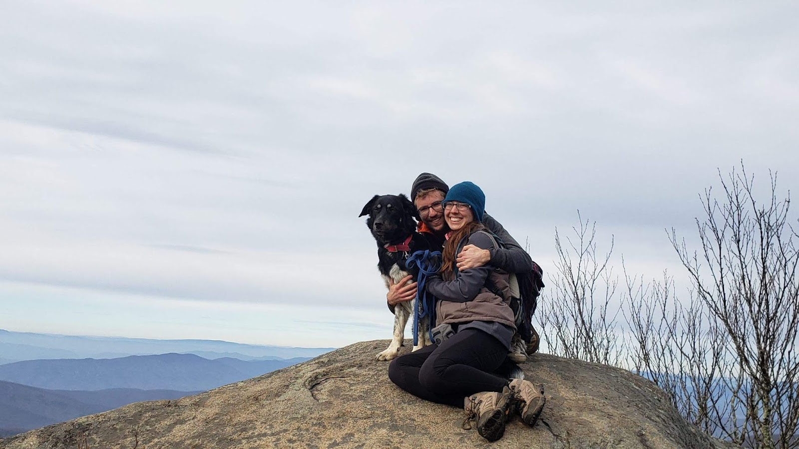
Casey, Honey, and I at flat top overlook

En route to fallingwater cascades

Honey makes a friend :)

At the overlook

Casey and Max

Cross rock.  It was a short, but STEEP detour to get here.

Honey Bunny Bear and I