Thursday, December 5, 2013

Sharp Top - Peaks of Otter

I haven't been on top of adding this hike to my blog.  Unfortunately, the downside of being a college student is that work and tests tend to come in waves - this week has definitely taken its toll.  I'm off to another exam in a bit (leading me to the question of why professors think that it is acceptable to begin a 2 hour long assessment at 8:30 PM), but that's beside the point.  I figured that I was well overdue for a study break and I might as well update the blog.

My dad and I hiked Sharp Top the day after Thanksgiving amidst the masses who also decided that it was a perfect day for a hike.  It was my second time doing this little (but steep!) hike, but my dad had never been there before and wanted to go.  The hike was much like I remembered it, although my dad berated me for not giving him ample preparation on the steepness of the hike.  Isn't it funny how things tend to get lost in translation?  Regardless, we both had a good time despite the hoards of people.  I like people.  I really do.  But by god - I don't understand the sheer lack of etiquette that people continuously employ.  I encountered a handful of (older) children who insisted on following six inches behind my heels on the way down the icy path (presumably in an effort to make me speed up or somehow get around me).  They were like untrained puppies who bounce behind you as you open the front door just waiting for the opportunity to shoot out the door ahead of you.  Except they weren't untrained puppies.  They were untrained children.  As I waited for them to ask to pass me instead of merely invading my personal space, they joked about the number of wipeouts each had had while on the walk.  Beautiful.  I climbed out of the way to let them pass.

But I really shouldn't complain - overall it was a nice hike on a nice day and my dad and I had some very enjoyable bonding time.  Even the dog had fun.

Boo enjoys the view

Saturday, November 23, 2013

Old Hotel Trail/Cole Mountain Loop

   I never cease to be amazed at the views that Virginia has to offer.  Casey, Boo, and I did this little hike on our way home from school for Thanksgiving break.  I was a little hesitant as to whether my 9 year old dog would be able to handle the 6.4 mile loop, but I needn't have worried.  She did wonderfully.  It was a Friday in November, chilly and a bit bleak, so there were few others out with us.  We drove the bumpy several miles up a tiny gravel road before parking ourselves at the trail head.  With no other humans in sight and no vehicles parked in the same lot, I decided to let the dog explore a bit.  Boo has a tendency to chase all that runs and so I worry about her making a mad dash into a road after a deer, but with no well traveled roads in a several mile vicinity, I decided that it would be okay to give her a bit of freedom.  She took to the trail immediately and we all had a great time.
Boo explores the meadow at the top of the mountain

Boo and I enjoy the views

   We followed the "Hotel Trail" (AKA "Old Hotel Trail") for several miles until it intersected with the AT at which point, we continued on along the AT northbound towards the ridge.  I knew that I should be expecting a bald mountaintop, but as often seems to happen, the magnificence of the peak surprised me.  The meadow was vast and the views, even on a dreary day, were picture perfect.  And interestingly, some way, somehow, someone apparently manages to bring a mower up to the top of the this mountain, because the meadow was mowed just short enough to wander freely across it.  We continued Northbound on the AT until eventually it intersected with the road that we had driven up, at which point we walked the remaining .2 miles back to the car along the gravel road.  A great time was had by all.

near a campground along the way up

climbing toward the ridge

Casey and Boo at an overlook shortly before reaching the bald summit


Wednesday, November 6, 2013

Devil's Marbleyard

 I went back to the Devil's Marbleyard for something like the 5th time last Saturday.  Let me tell you something - this hike never gets old.  It is by and far one of the most interesting hikes that I've stumbled across in the region and I have yet to find anything else quite like it.  Whenever someone asks me what hikes I would recommend, I mention this little gem of a hike.  And each and every time I decide to hike it myself, I think I know what to expect.  Yet, without fail - I am always freshly amazed at how incredible this pile of boulders actually is.  Photos do not do it justice.  Unfortunately, in a photo it is difficult to accurately frame the angles and true sizes of the rocks.  In real life, you'll realize that this rock scramble is not a short horizontal jaunt across a pile of printer sized boulders.  Rather, it's a seriously uphill climb of roughly .5 miles up a field of boulders ranging in size from that of a soccer ball to that of a large truck.
Me climbing up one of the lower portions


Foamhenge - from a previous trip
My friends and I started our journey on Saturday with a trip to Foamhenge - a must see if you're already on your way to the marbleyard.  Foamhenge is more funny than it is spectacular, but never-the-less, it provides a good chuckle and photo opportunity.  Plus, it's only about a mile out of the way. except for the marbleyard.  And so, it seems to be a recurring trend that I forget that there is actually a bit of a walk before you'll reach the base of the boulders.  Either way, it's a short jaunt, albeit a slightly uphill one - but a forgettable one once you see the boulder field to your left.

From there, we headed to the marbleyard.  I always underestimate how long the hike to the base of the marbleyard takes.  Really, it's not very long at all (a little over a mile along the Belfast trail if I remember correctly), but after returning to the car after doing the marbleyard, it's hard to remember much of anything

I brought Casey (who I am convinced is part mountain goat), Elena (who was new to the marbleyard), and Casey #2 (because my friend group has an unhealthy number of name duplicates).  Also there were Kevin and Courtney and a few of Courtney's friends.  It was a thrilling, yet relatively uneventful trip up the boulders (namely - no one died or broke a leg).  I cheated just a bit as we neared the top by cutting off to a makeshift trail along the side of the boulder field, but eventually the entire party reached the top edge.
The whole party on the way up

We took the easy way down, sliding along the side of the field, rather than rock scrambling our way back down.  We saw a little fence lizard (I think that's what it was called!) and had a record for the least number of wipeouts on the loose footing on the way down.  I still managed to land on my butt once, but after managed to stay on two feet.  All in all - a great trip. 

By the way - some of these photos are mine from older trips and some belong to friends and are from this trip.  I wasn't bothered to bring my camera this time around.

Casey and I from a previous trip

Saturday, October 19, 2013

Grandfather Mountain

The beautiful blue ridge parkway

 
I am exhausted.  And sore.  And beyond thrilled that I was able to complete such an amazing hike and visit such a wonderful place.

Casey and I headed to Asheville for our fall break from school on Thursday night.  Unfortunately, no one else was able to join us, but we made the most of the overnight trip by touring the town on Thursday night and hiking Grandfather Mountain on Friday.  Asheville was everything that I had hoped it would be.  The character of the town was unmistakable and on every block, its eclectic personality shone through in the music of street performers, the outfits of the passers-by, and the arrangements of ornaments framed in the windows of the shops that lined the street.  Our first stop was a little book shop that had received glowing recommendations from tripadvisor.com.  Trip Advisor didn't lie.  The used book shop was a labyrinth of shelves, interrupted only by comfy old chairs with little tables in between.  The first level was a wine bar, where individuals could buy their choice of drink to bring to their table amidst the shelves.  The very best part?  The entire place was dog friendly.  Three golden retrievers on leashes greeted us as we were leaving the building.

Because we arrived later in the day, the majority of the shops were closed to all but window shopping, however a good few remained open and we were able to poke around.  A little gallery of modern art touted itself as also being pet friendly and boasted fascinating artwork on its walls.  Another shop smelled strongly of incense and provided entertaining browsing with its odd objects.  Each block held restaurants of every type and scale.  We ate at a little pizzeria place with a fun live jazz band.  A tiny central park/amphitheater rested in the center of the downtown area with chess board tables surrounding the perimeter.  The place was brimming with life of people of all ages and walks of life.  I was in love. I can't even imagine how amazing the weekends might be.  I would love to someday live nearby.

Our "cabin"
We left Asheville on Thursday night after dinner and headed to a little campground about thirty minutes outside of town.  Because there was a chance of rain, we opted for a small cabin instead of a tentsite.  Ours was hilarious.  I am fairly convinced that the owners bought a handful of children's playhouses and then rented them nightly as "playhouse cabins."  The thing was adorable.  The door was roughly three feet high, but the interior was surprisingly spacious, with sleeping room for probably 6 or so adults.  I'm glad we didn't come with any preconceived notions, as the cabin could have proved a disappointment, but as it was, I just loved the thing.
MacRae Peak

profile view of Grandfather Mountain
Our new garter snake friend
Waking up at O'dark thirty has its benefits, and ours was seeing a heavenly looking fog as we drove through sunrise to Grandfather Mountain.  We opted for a cheap trip and chose to park in a lot outside the park entrance and make the longer hike to the peaks.  The first three miles of the hike along Profile Trail were fairly average, although certainly steep and tiring.  Upon reaching the trail junction, however, the hike took on a new life.  This hike along grandfather trail quickly became one of my top all-time hikes on the East Coast.  There were ladders in areas, cables to help hikers scale rock faces, and astounding views that presented themselves at every corner.  A particularly ugly hotel marred the view on one side just a bit, but the view to the other side of the mountain was breathtaking, especially with the fall foliage.  We saw another little snake - this one a Garter snake (and much smaller than our Rat snake acquaintance from rice fields) that I also nearly stepped on.  Other than that, there was not too much wildlife spotting, but the structure of the trail made up for it.  It was definitely a strenuous 9.2 miles, but very well worth it.


And now today, as I wake up in my own bed, muscles that I didn't even know existed are aching, but I'm so thrilled that I was able to experience this gorgeous hike.  And plus - it afforded me the chance to stand on the highest point in the Blue Ridge Chain.  What a wonderful start to the weekend.

Today, I'm thrilled to head to the Roanoke Go Outside Festival and watch some dock dogs.  Life is good.


A nice little rock scramble
Me and Casey at MacRae Peak
Some Autumn views

Rice Fields


The beautiful rice fields
A few weeks back, Elena, Casey and I headed off to rice fields.  This was a momentous occasion - the final hike to still be completed on Venture Out's "Top Ten Hikes Near Virginia Tech" list.  Not that this list is anything special.  Venture Out is just a little outdoorsy shop on campus that happened to put together a list of their favorite Southwest VA hikes.  And not that it should've taken me over three years to finish the darn list.  But it did.  And on October 5th, 2013, I finally finished the darn thing.

Rice Fields again
Don't get me wrong.  I've done the Cascades at least four or five times, Kelly's Knob the same number.  Dragon's Tooth and Angel's Rest have seen me twice.  I'm a fairly frequent visitor to the Devil's Marbleyard.  But alas, I had not finished the list.

Rice field lived up to the excitement that had started to fester in me as I realized that I would actually complete this mini goal before graduation.  Though the hike up was essentially two miles of plugging up the mountain with few breaks, the two mile mark or thereabouts made for a nice change.  The trail evened out into a nice ridge trail that wove its way over fairly level ground until it opened up into a vast meadow, aptly dubbed rice field (or nearly aptly dubbed seeing as there was no rice - but I suppose the image of the meadow atop the mountain was enough to spark visions of rice fields in lands far away).  As the trail mellowed, my stride lengthened, I breathed more easily, and I quickened the pace.  And then, as I looked down at the ground in front of me I noticed something different.  My momentum carried me into the next step and I took off shrieking like an offended puppy.  The snake was about four feet long and looked particularly menacing right as I nearly stepped on the thing.

The black rat snake, after Elena poked him
Elena and Casey, safely in the back of the line, stopped where they were and laughed at me until I inched back to where I'd started.  Don't get me wrong.  I don't dislike snakes.  They're quite beautiful and in the times that I've had the chance to hold them, I've realized that they're actually pretty cool animals.  But by god, I was not prepared to almost flatten one with my foot.  We took pictures and posed with the seemingly unperturbed snake until Elena poked him with her finger at which point he decided that "fight" should beat out "flight."  I took that as my cue that it was time to continue walking.  Elena took it as hers that it was time for an epic photo shoot.  Needless to say, no one was harmed in the process - but I was slightly disheveled and the not so little rat snake had decided we were not friends.

eating questionable weeds
We made it to the fields with no more exciting incidents, although the hike in and of itself was nice.  When we arrived, I curled up on the ground with my sleeping bag as a pillow and took in the breeze.  Casey and Elena thought I was silly for bringing a sleeping bag on a day hike.  They have a point, I'd reason to admit, but when we get stuck overnight for some bizarre reason, they'll be happy that I lugged the two pounds of fabric up the mountain with me.  The views were magnificent, the fields were awesome, and I got to try my hand at eating some weird root vegetable that Elena claimed was edible.  The root of Queen Anne's Lace maybe?  I'm not dead yet, so I suppose she was right.

In other news, Sassafrass tastes like apricots.  Try it sometime.


Monday, September 30, 2013

Fuller Rocks and Big Rocky Row

I never would have guessed that the James River snakes its way into Southwest Virginia.  I have memories of my childhood self, sitting on a rock outcropping alongside this same river with a fishing pole in hand, reeling in catfish.  But that was in Williamsburg, and well before the days of college or hiking.  So upon reading about a little stretch of Appalachian Trail that would afford me views of the James - and apparently some of the best views in Virginia - I decided this was a hike worth pursuing.  My source slated this trip as a loop, but as I would soon figure out - this was not quite the case.

Casey and I departed from Moneta, VA, after a nice trip to visit my mother and my darling dog.  I wanted more than anything to bring the dog on our excursion, but after a short two mile neighborhood stroll the previous day leaving her panting and sprawled on the floor, we decided it best to leave her to the comfort of the couch.  She was not thrilled with this plan and watched us leave with a face to rival that of Puss and Boots.

Casey being skeptical of my photography
We arrived at this hike after an hour's drive that took us through the Bedford County Fair (or something of that regard).  The hike itself was typical of the area - wooded, dirt, and hilly.  We reached our first overlook after a less than fun 22 switchbacks that reminded me of Angel's Rest and its relentless incline.  The view of the river was beautiful.  The Fuller Rock overlook is actually little more than a view straight off the side of the Appalachian Trail, making for less than ample room when other hikers cross paths while one is enjoying the view.  Fortunately, just slightly up from this overlook, we found several more as we continued on our way to Big Rocky Row.  If the switchbacks were tiring, the ascent to Big Rocky Row summit was even steeper.  We ascended the last 550 feet and found our last overlook.  It was splendid, although questionable whether the (nearly identical) views were worth the extra climb.  After taking in our fill of forested mountainsides and river views, we set to continue on with our loop. 

View from Big Rocky Row
I had read that the conjoining trail was less traveled than the Appalachian Trail and a bit overgrown, but we decided that it wouldn't be too bad.  We wandered the final mile stretch and came upon the sign to the Saddle Gap Trail, which was to take us back to the road upon which we had parked our car.  The sign was there, good as new, and a slightly less traveled trail split to the right for about 20 feet.  Beyond this, however, there was no discerning trail from woods.  The overgrowth had taken over and little prickers grabbed our shoelaces and pants.  Just as we were sizing up the situation and deciding whether we should just turn our hike into an "out and back," I spotted something large and brown and squishy near my foot, right in the middle of the trailless trail.  Bear poop?  Dog poop?  I wasn't quite sure.  And then I saw the toilet paper.

I cautiously picked up my boot.  And there it was - a disgusting pile of human crap embedded into the traction of my boot.  And so we turned around, me dragging my boot through the grass and leaves, and Casey trying to guess which passerby that we had met during our ascent was the owner of the pile of crap now clinging to my shoe.  And finally, after two miles more than anticipated, we made it back to the car.  My shoe, though by that point crapless, was

banished to the trunk.

Sunday, September 8, 2013

Mount Rogers

picking burrs out of a pony mane
Weller's Salamander
I'm finally done with the West updates and able to get back to those Virginia hikes.  I'm not going to lie - hiking on the West coast was amazing.  But hiking in Virginia is just as magnificent in its own way.  Mount Rogers is home to the highest point in Virginia and, unless I am mistaken, is one of the only states in the region with a "state high point" that is not accessible by car.  We did the hike to the summit from the Massie Gap parking lot.  The round trip distance was probably 8-9 miles and absolutely beautiful.  Even more, the area is home to a handful of "wild" ponies that are used to keep some of the vegetation in check.  While actually quite far from wild (the ponies like head scratches and to scan your pockets for treats), it was great fun to experience them. 

At the (very poorly marked) summit
Interestingly enough, the Mount Rogers summit is one of the few areas of this hike that doesn't have a view.  Instead, the summit is covered by a spruce-fir forest.  Despite the lack of views near the top, we had a great time looking for salamanders and did not come up empty handed.  Alex, the resident herp guy, managed to find a few Weller's salamanders which are apparently only found on a handful of mountains - Mt. Rogers included.

Overall, it was an amazing hike on a beautiful day.  I can't wait to make a backpacking trip of it at some point in the near future.
At an overlook along the way

 **these photos belong to a friend and were not taken by me**


Inyo National Forest - Lone Pine Lake

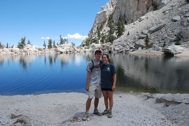
This is the last of my "Out West" updates.  After leaving Yosemite, Casey and I headed to Inyo National Forest where we met up with my sister and her husband.  The two of them were planning to hike Mt. Whitney and wanted to acclimate to the altitude before attempting the 22 mile trek.  Casey and I joined them on one of their shorter day hikes up to Lone Pine Lake.  Situated on the Mt. Whitney trail, the lake was absolutely breathtaking.  A few bold souls were actually swimming in the lake, but at roughly 10,000 feet in elevation, it was as much as I could do to dip my hand.

A beautiful view of the mountains on the drive to Mt. Whitney Campground

The reason why not to blindly follow your GPS

Lone Pine Lake

A few of the pines

Casey and I at the lake

Reflections in Lone Pine Lake

everyone napping

hungry, hungry mule deer

Tuesday, August 27, 2013

Yosemite

Moving on to post number two of my trip to the West - this one about Yosemite National Park.  Although I don't plan to spend too much time physically typing about my adventures here, I feel the need to state the obvious.  This area is absolutely stunning.

We made our first stop at Glacier point - a whopping .1 mile stroll down a paved path from the parking lot.  Despite the hoards of people taking in one of the most popular views in the park, I do think that it was worth the drive from our campground.  Even more, we managed to power-walk our way up the nearby Sentinel Dome to catch most of the sunset.  Keep in mind that these photos are a bit deceiving - Casey and I posed atop a rock in an effort to cut out the heads of the dozens of people milling around.

Glacier Point
Me and Casey at Glacier Point

View of half dome from Glacier Point


Sentinel Dome

This was just a short 2.2 mile hike (1.1 miles each way).  We made our way up quickly in order to catch most of sunset and were gifted with gorgeous views of the night sky on the way back.

The sun starting to set on the way up

The side of approach

atop the dome

atop the dome

Mt. Hoffman

 The day following our arrival, we decided to embark on a 6 mile hike up Mount Hoffman and back.  It took my breath away - quite literally.  The effects of altitude are pretty impressive and I found myself out of breath much more quickly than usual.  That said, the 2000 vertical feet climbed over 3 miles to the peak would have taken its toll on me regardless of the location.  Despite my constant need for breaks, the hike was incredible and the views unreal.

May Lake

Chipmunk at May Lake

View of May Lake from the Trail

Snow in August!

More incredible views


View on the way down

Vernal Falls

On the day following our hike to Mt. Hoffman, we decided to head down in elevation to Yosemite Valley.  The hike to vernal falls was short at only 1.5 miles each way, but steep and extremely crowded the whole way up.  I wasn't a fan of the hike's popularity, but the waterfall was worth it.  Even in August with just a small flow, it was pretty breathtaking, especially when the sun shone at just the right angle to create a beautiful rainbow in the mist.

Vernal Falls in August 2013

Rainbow in the falls

Rainbow in the falls

Tuolumne Meadows

On our final full day in the park, we headed to tuolumne meadows and spent our time wandering up to pothole dome and then along the river.  The river could easily have been my favorite place in the park.  We followed a fisherman's trail and then walked a few miles down the river, passing crystal clear swimming holes and sliding rocks along the way.  All this with just a handful of other people.

View from Pothole Dome

Walking up Pothole Dome

Casey and I on Pothole Dome

Mule deer in Tuolumne Meadows

The meadows

One of the crystal clear swimming holes

Another river view

Some small falls